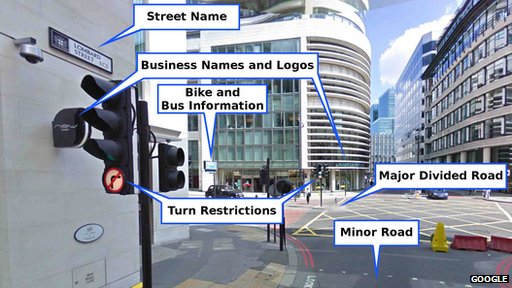
 Google recently explained the magic behind its mapping system–something called “Ground Truth”
“We decided to start a project called Ground Truth, and this was really to build our own maps from scratch. We would start with licensed data and we would find whatever we could where we could get full rights to the data and improve it from there.” . . . .
But Google’s computers also analyse the images to identify street signs, speed limits, addresses, business names, rights of way at road junctions and other information. Human operators then check over each area to correct mistakes before the data is incorporated into the maps.
“The benefits of having Street View can’t be undercounted,” Mr McClendon says.
“We have over 20 petabytes [21.5 billion megabytes] of imagery and have driven and published over five million miles of Street View roads.”
So what is in store for the future of ground truth? Well this is the internet after all–“Ground Truth 2.0” (that means mapping India)
So far the Ground Truth project covers 31 nations – places where there was already decent data Google could license to use as the foundations for its process.
Now it is about to embark on what it calls Ground Truth 2.0, extending the system to “more difficult” regions.
Top of its list is the country with the world’s fastest growing population.
“There hasn’t been a good map that has named all the villages in India to date,” says Mr McClendon.
And mapping the *inside* of properties:
Beyond Ground Truth, Google also aims to improve its service by mapping the interiors of more buildings – the current emphasis is on transport hubs, shopping centres, museums and business that pay for an approved photographer to visit them.
However, Mr McClendon draws the line at the idea of adding people’s homes.
“I think private is something Google wants to stay out of,” he says.
Sure, what could go wong.
H/T Gizmodo