TechCrunch has a great history of how Street View began.
Google decided to invest a little money into more experiments to see if it was feasible to take photos of every street in San Francisco, as Levoy and one of his students had come up with a way to shoot video and paste it together into one picture. By parsing out this video frame by frame, it could make a really “long” image, or a facade of an entire street. It was distorted, of course, but this was the building block that Google needed to prove out its Street View theory.
On these long, wiggly, very early street-wide images, Vincent said “That was interesting to us.” Pretty to the point, and that was the moment that Street View was born.
After this testing, Larry Page strapped a camera onto his car and snapped shots throughout San Francisco. These images, along with some very basic cross-street data, would be patched together into something that wasn’t quite useful, but was even more “interesting,” as Vincent would put it.
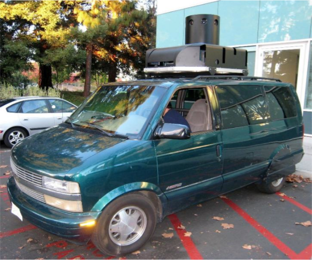
From Page’s car, the very early Street View team, which was made up of infamous 20% time from a few random Googlers, threw some cameras into a van with a GPS and some lasers. The lasers were to grab data so that the team could know what the distance was between the camera and the facades of the buildings. That spacial recognition is what helps Google patch all of its images together and give it that 3D feel. The camera took a lot of pictures, the devices, hooked up to a raid of computers in the back of the van, and then this very unique dataset that is what makes Street View, Street View, was amassed. It wasn’t pretty though, as Vincent shared:
It was a Frankenstein looking car, but it let us capture enough data in the Bay Area. We had a van that we borrowed from the security team. It would go into the city, do some driving, and things would stop working and the computer gave us errors.
I remember exactly where I was when I first discovered Google Street View. I was sitting in an information privacy class during the summer of 2007, after my first year of law school. I was surfing the web in class (who said that as a bad idea?) and came across Street View. I was stunned, absolutely stunned. I wondered at first, how in the hell did Google get all these images. Initially, Google only launched in San Francisco. At the time, Google was offering free WIfi to SanFran. I wondered if perhaps they placed cameras on their wifi towers? I had no idea. Eventually, I figured out that the images were taken by moving cars. At the time, I asked my Professor–after all it was an information privacy class–is this legal!? Can Google take pictures of people in public? When it was first launched, faces were not blurred. My professor told me, that under prevailing law, it was perfectly legal. If you are in public, there is a right to privacy. I said, that can’t be right. Look at what Google is doing!? At that moment, Omniveillance was born.
I wrote the paper for the class that summer. Well in truth, I wrote the entire article in about 72 hours (I have never came closer to an all-nighter in my life, to this date).I got an A on the paper. I then turned it into my law review note. The journal did not like it, telling me that it was unrealistic. A professor told me, who are you investing a tort. Do you think you are Richard Epstein or something? I went ahead and submitted it on ExpressO (not even sure how I knew what that was) at my own cost. Boom. I got an offer with the Santa Clara Law Review, and was selected as the lead article. The editor told me that he was quite relieved that his journal accepted student submissions.
Anyway, long story short, but the introduction of Google Street View formed the beginning of my academic career. My initial freakout that something was off about this new technology perhaps the first step in my scholarly arc. For that, I am grateful.
